
- 1c++多进程编程
- 2git命令使用-fetch_git fetch
- 3安装达梦(DM8)数据库(图形化安装)_达梦安装
- 4Stable Diffusion简介_stable diffusion 是做什么的
- 5openwrt 开发外围准备工作:(二)winscp 与更新luci主题_opkg luci-theme-openwrt
- 6ARM架构以及程序运行解析_arm架构要怎么用
- 7SpringBoot依赖之Spring Data Redis一有序集合Sorted Set
- 8Oracle RAC简介:什么是Oracle RAC集群?
- 9【Qt笔记】QLabel控件详解
- 10LLM成功不可或缺的基石:RLHF及其替代技术
OceanBase V4.2特性解析:MySQL模式下GIS空间表达式的场景及能力解析_ocenbase postgis
赞
踩
1. 背景
1.1. OceanBase Mysql gis空间表达式的应用场景及能力
在OceanBase 4.1版本中,mysql模式下支持了gis数据类型以及部分空间对象相关的表达式,随着客户使用空间数据的需求日益增长,需要快速地补齐空间数据存储和计算分析的能力;
针对mysql的空间表达式的能力,目前补齐了部分gis表达式,包括:
- 空间关系计算表达式:判断空间关系是否成立(ST_Crosses/ST_Overlaps)
- 空间对象计算表达式:根据输入的空间对象计算出新的空间对象(ST_Difference/ST_Union/ST_SymDifference)
- 空间对象测量表达式:测量空间对象长度(ST_Length)
- 空间对象分析表达式:计算空间对象质心点(ST_Centroid)
- 空间对象格式转换表达式:空间对象转换为json类型(ST_AsGeoJSON)
pg作为gis行业使用最广的数据库,提供了部分空间表达式的功能是mysql不具备的,且该部分表达式也被广泛应用,同时pg还支持3维空间对象存储。因此ob在兼容mysql gis的能力基础上也对空间表达式的能力进行了扩展补充,作为ob mysql模式下特有的空间表达式(这部分空间表达式以'_'做为前缀);包括以下几类:
-
- 空间关系计算表达式:判断空间关系是否成立(_ST_Touches/_ST_Equals)
- 空间对象构造表达式:构造空间对象(_ST_MakeEnvelope/)
- 空间对象计算表达式:根据输入的空间对象计算出新的空间对象(_ST_ClipByBox2D)
- 空间对象属性访问表达式:查询空间对象某一属性(_ST_GeometryType/_ST_IsCollection/_ST_NumInteriorRings)
- 空间对象分析表达式:计算一个保证位于几何体内部的点(_ST_PointOnSurface)
- 空间对象格式转换表达式:空间对象转换为mapbox vector tile格式(ST_AsMVTGeom/_ST_AsMVT)
ob mysql gis也支持了3维空间对象的存储能力。
1.2 OceanBase v4.2.2,Mysql gis空间表达式的特性支持
OceanBase 4.2.2版本下新增的兼容mysql gis空间表达式如下:
| 表达式名称 | 功能介绍 |
| boolean ST_Crosses(geometry g1, geometry g2) | 判断两个Geometry g1和g2在空间上是否有交叉,即几何体内部有部分点相同,但不完全相同 |
| boolean ST_Overlaps(geometry g1, geometry g2) | 判断两个几何体是否空间上相交且具有相同的维度,但并不完全互相包含。 |
| geometry ST_Difference(geometry g1, geometry g2) | 返回geometry g1中不和geometry g2相交的部分,等价于g1 - ST_Intersection(g1, g2) |
| geometry ST_Union(geometry g1, geometry g2) | 返回geometry g1和geometry g2的并集 |
| geometry ST_Length(geometry g1, unit string) | 计算LineString类型或MultiLinestring类型的长度,该长度和线段所在空间坐标系有关,MultiLinestring类型的长度等于其包含的LineString长度之和;unit参数指定了长度显示单位 |
| geometry ST_SymDifference(geometry geomA, geometry geomB) | 返回geometry A和Geometry B不重叠的部分,等价于ST_Difference(ST_Union(g1, g2), ST_Intersection(g1, g2))。 |
| ST_AsGeoJSON(g [, max_dec_digits [, options]]) | 将geometry转换为对应的json格式,包含两个可选参数max_dec_digits和flag。 |
| ST_Centroid(geometry A) | 计算几何体的质心点,该质心点不保证在几何体上 |
此外,新增ob mysql特有gis空间表达式如下:
| 表达式名称 | 功能介绍 |
| geometry _ST_PointOnSurface(geometry g1) | 返回一个保证位于几何体内部的点,和ST_Centroid不同,ST_Centroid返回的中心点不一定在几何体上 |
| geometry _ST_MakeEnvelope(float xmin, float ymin, float xmax, float ymax, integer srid=unknown); | 该函数通过输入左下角坐标与右上角坐标,构造一个矩形; |
| geometry _ST_ClipByBox2D(geometry geom, box2d box); | 通过Box快速剪裁几何体,不会检查输入几何体的合法性,也不保证输出的几何体是合法的。该函数第二个参数虽然是Box,但实际上可以输入任意Geometry,会隐式转换为Box |
| text _ST_GeometryType(geometry g1); | 返回Geometry的类型 |
| boolean _ST_IsCollection(geometry g1); | 判断输入的Geometry是否为集合类型 |
| integer _ST_NumInteriorRings(geometry a_polygon); | 返回Polygon的内环数,如果Geometry非Polygon类型,则返回NULL |
| boolean _ST_Touches(geometry A, geometry B) | 判断两个Geometry A和B边界是否至少有一个共同点,且内部不相交。注意若两个Geometry均为Point类型,直接返回false,因为Point没有边界 |
| boolean ST_Equals(geometry A, geometry B); | 判断两个Geometry A和B是否在空间结构上相等,即包含相同的点集,但不考虑点集顺序是否一致 |
| bytea _ST_AsMVT(table_name.*, text name, integer extent, text geom_name, text feature_id_name); | 将一组行聚合返回一个使用Google Protocol Buffers编码格式二进制的mapbox矢量瓦片,blob类型;第一个参数是必须的,后面的参数可选 |
| geometry _ST_MakeValid(geometry input); | 尝试将输入的无效的多边形修复为一个有效的多边形 |
| geometry ST_AsMVTGeom(geometry geom, // 输入空间对象 box2d bounds, // MVT空间坐标范围 integer extent=4096, // 矢量切片的范围(4096个单位) integer buffer=256, // 缓存区大小 boolean clip_geom=true); | 将一个输入的空间对象转换到bounds定义的map vector tile空间坐标系下,超出bounds的部分且位于buffer指定的缓冲区以内的部分根据clip_geom参数的配置来决定是否裁剪;map vector tile空间坐标系起始点位于左上角(屏幕参考系);转换后输出的满足mapbox vector tile 规范的有效geometry,常作为st_asmvt的入参。 |
支持3维gis数据存储,gis表达式适配3维数据分类如下:
- 输入WKT/WKB格式数据构造空间对象的表达式,支持输入3维数据构造空间对象;
- 将存储的空间数据转换成指定格式WKT/WKB/EWKB/EWKT输出的表达式,支持查询3维空间数据;
- 不支持输入3D数据;
| 类型 | 表达式 | 功能 | 适配内容 |
| 构造空间对象 | st_geomfromtext | 输入wkt格式创建几何值 | 如果是3d geo,跳过检查经纬度范围的逻辑;封装geo_to_wkb,增加3d-wkb格式转成swkb; |
| st_geometryfromtext | 输入wkt格式创建几何值 | ||
| _st_geomfromewkt | 输入ewkt格式创建几何值 | 同上 | |
| _st_geogfromtext | 输入wkt格式创建几何值,默认geography坐标系 | 同上 | |
| _st_geographyfromtext | 输入wkt格式创建几何值,默认geography坐标系 | ||
| st_geomfromwkb | 输入wkb格式创建几何值 | 增加校验3d wkb格式是否合法 | |
| st_geometryfromwkb | 输入wkb格式创建几何值 | ||
| _st_geomfromewkb | 输入ewkb格式创建几何值 | 3d-ewkb和iso 3d-wkb的type表示的方式不一样,需要做转换同样需要校验输入的wkb是否合法 | |
| 格式转换 | st_astext/st_aswkt | 输出wkt格式 | 读取swkb转换成geo对象,然后转换成3d-wkt格式。 |
| st_aswkb/st_asbinary | 输出wkb格式 | swkb转wkb | |
| _st_asewkb | 输出ewkb格式 | ewkb转wkb | |
| _st_asewkt | 输出ewkt格式 | wkt前面需要加上"srid=xxx" | |
| 空间计算表达式 | st_area | 计算空间对象面积 | 将3维空间数据转为2维处理 |
| st_intersects | 计算两个空间对象是否相交 | ||
| st_transform | 将一个空间对象的坐标转换到指定的空间坐标系下 | ||
| _st_covers | 计算空间对象A是否包含空间对象B | ||
| st_buffer | 计算一个距离小于或等于给定距离的所有点的POLYGON/MULTIPOLYGON | ||
| st_distance | 计算两个空间对象间距离 | ||
| _st_dwithin | 计算空间对象A是否在一定距离内被包含于空间对象B | ||
| st_distance_sphere | 返回球体上两个点和/或多点之间的最小球面距离 | ||
| st_contains | 计算空间对象A是否包含空间对象B | ||
| st_within | 计算空间对象A是否包含于空间对象B | ||
| ST_Crosses | 判断两个Geometry g1和g2在空间上是否有交叉,即几何体内部有部分点相同,但不完全相同 | ||
| ST_Overlaps | 判断两个几何体是否空间上相交且具有相同的维度,但并不完全互相包含。 | ||
| _ST_Touches | 判断两个Geometry A和B边界是否至少有一个共同点,且内部不相交。注意若两个Geometry均为Point类型,直接返回false,因为Point没有边界 | ||
| ST_Equals | 判断两个Geometry A和B是否在空间结构上相等,即包含相同的点集,但不考虑点集顺序是否一致 |
- 以下表达式支持空间索引
| 表达式名称 | 功能介绍 |
| boolean ST_Crosses(geometry g1, geometry g2) | 判断两个Geometry g1和g2在空间上是否有交叉,即几何体内部有部分点相同,但不完全相同 |
| boolean ST_Overlaps(geometry g1, geometry g2) | 判断两个几何体是否空间上相交且具有相同的维度,但并不完全互相包含。 |
| boolean _ST_Touches(geometry A, geometry B) | 判断两个Geometry A和B边界是否至少有一个共同点,且内部不相交。注意若两个Geometry均为Point类型,直接返回false,因为Point没有边界 |
| boolean ST_Equals(geometry A, geometry B); | 判断两个Geometry A和B是否在空间结构上相等,即包含相同的点集,但不考虑点集顺序是否一致 |
2. 使用操作
2.1. ST_Crosses(g1,g2)
支持空间索引,判断两个Geometry g1和g2在空间上是否有交叉,即几何体内部有部分点相同,但不完全相同。
- OceanBase(root@oceanbase)>select st_crosses(st_geomfromtext('LINESTRING(1 1, 11 11)'), st_geomfromtext('POLYGON((0 0, 0 10, 10 10, 10 0, 0 0))'));
- +------------------------------------------------------------------------------------------------------------------+
- | st_crosses(st_geomfromtext('LINESTRING(1 1, 11 11)'), st_geomfromtext('POLYGON((0 0, 0 10, 10 10, 10 0, 0 0))')) |
- +------------------------------------------------------------------------------------------------------------------+
- | 1 |
- +------------------------------------------------------------------------------------------------------------------+
- 1 row in set (0.004 sec)
2.2. ST_Overlaps(g1,g2)
支持空间索引,判断两个几何体是否空间上相交且具有相同的维度,但并不完全互相包含。
- OceanBase(root@oceanbase)>SELECT ST_OVERLAPS(ST_GEOMFROMTEXT('POLYGON((0 0,0 10,10 10,10 0,0 0,0 0),(2 2,2 4,4 4,4 2,2 2))'), ST_GEOMFROMTEXT('POLYGON((0 0,0 5,5 5,5 0,0 0))'));
- +-------------------------------------------------------------------------------------------------------------------------------------------------+
- | ST_OVERLAPS(ST_GEOMFROMTEXT('POLYGON((0 0,0 10,10 10,10 0,0 0,0 0),(2 2,2 4,4 4,4 2,2 2))'), ST_GEOMFROMTEXT('POLYGON((0 0,0 5,5 5,5 0,0 0))')) |
- +-------------------------------------------------------------------------------------------------------------------------------------------------+
- | 1 |
- +-------------------------------------------------------------------------------------------------------------------------------------------------+
- 1 row in set (0.005 sec)
2.3. ST_Difference(g1,g2)
返回geometry A中不和geometry B相交的部分,等价于A - ST_Intersection(A, B)。
- OceanBase(root@oceanbase)>SELECT ST_AsText(ST_Difference(ST_GeomFromText('LINESTRING(50 100, 50 200)'),ST_GeomFromText('LINESTRING(50 50, 50 150)')));
- +----------------------------------------------------------------------------------------------------------------------+
- | ST_AsText(ST_Difference(ST_GeomFromText('LINESTRING(50 100, 50 200)'),ST_GeomFromText('LINESTRING(50 50, 50 150)'))) |
- +----------------------------------------------------------------------------------------------------------------------+
- | LINESTRING(50 150,50 200) |
- +----------------------------------------------------------------------------------------------------------------------+
- 1 row in set (0.004 sec)
2.4. ST_Union(g1,g2)
返回geometry A和geometry B的并集
- OceanBase(root@oceanbase)>SELECT ST_AsText(ST_Union(ST_GeomFromText('LINESTRING(50 100, 50 200)'),ST_GeomFromText('LINESTRING(50 50, 50 150)')));
- +-----------------------------------------------------------------------------------------------------------------+
- | ST_AsText(ST_Union(ST_GeomFromText('LINESTRING(50 100, 50 200)'),ST_GeomFromText('LINESTRING(50 50, 50 150)'))) |
- +-----------------------------------------------------------------------------------------------------------------+
- | MULTILINESTRING((50 100,50 200),(50 50,50 100)) |
- +-----------------------------------------------------------------------------------------------------------------+
- 1 row in set (0.004 sec)
2.5. ST_Length(ls[,unit])
unit参数指定了长度显示单位,默认为metre(米),常见的有foot、centimetre等。全部单位和其对应转换系数如下,当且仅当srid != 0且单位合法时生效。
- +--------------------------------------+---------------------+
- | UNIT_NAME | CONVERSION_FACTOR |
- +--------------------------------------+---------------------+
- | British chain (Benoit 1895 A) | 20.1167824 |
- | British chain (Benoit 1895 B) | 20.116782494375872 |
- | British chain (Sears 1922 truncated) | 20.116756 |
- | British chain (Sears 1922) | 20.116765121552632 |
- | British foot (1865) | 0.30480083333333335 |
- | British foot (1936) | 0.3048007491 |
- | British foot (Benoit 1895 A) | 0.3047997333333333 |
- | British foot (Benoit 1895 B) | 0.30479973476327077 |
- | British foot (Sears 1922 truncated) | 0.30479933333333337 |
- | British foot (Sears 1922) | 0.3047994715386762 |
- | British link (Benoit 1895 A) | 0.201167824 |
- | British link (Benoit 1895 B) | 0.2011678249437587 |
- | British link (Sears 1922 truncated) | 0.20116756 |
- | British link (Sears 1922) | 0.2011676512155263 |
- | British yard (Benoit 1895 A) | 0.9143992 |
- | British yard (Benoit 1895 B) | 0.9143992042898124 |
- | British yard (Sears 1922 truncated) | 0.914398 |
- | British yard (Sears 1922) | 0.9143984146160288 |
- | centimetre | 0.01 |
- | chain | 20.1168 |
- | Clarke's chain | 20.1166195164 |
- | Clarke's foot | 0.3047972654 |
- | Clarke's link | 0.201166195164 |
- | Clarke's yard | 0.9143917962 |
- | fathom | 1.8288 |
- | foot | 0.3048 |
- | German legal metre | 1.0000135965 |
- | Gold Coast foot | 0.3047997101815088 |
- | Indian foot | 0.30479951024814694 |
- | Indian foot (1937) | 0.30479841 |
- | Indian foot (1962) | 0.3047996 |
- | Indian foot (1975) | 0.3047995 |
- | Indian yard | 0.9143985307444408 |
- | Indian yard (1937) | 0.91439523 |
- | Indian yard (1962) | 0.9143988 |
- | Indian yard (1975) | 0.9143985 |
- | kilometre | 1000 |
- | link | 0.201168 |
- | metre | 1 |
- | millimetre | 0.001 |
- | nautical mile | 1852 |
- | Statute mile | 1609.344 |
- | US survey chain | 20.11684023368047 |
- | US survey foot | 0.30480060960121924 |
- | US survey link | 0.2011684023368047 |
- | US survey mile | 1609.3472186944375 |
- | yard | 0.9144 |
- +--------------------------------------+---------------------+

- OceanBase(root@oceanbase)>SET @ls = ST_GeomFromText('LineString(1 1,2 2,3 3)', 4326);
- Query OK, 0 rows affected (0.001 sec)
-
- OceanBase(root@oceanbase)>SELECT ST_Length(@ls, "foot");
- +------------------------+
- | ST_Length(@ls, "foot") |
- +------------------------+
- | 1029205.9131247795 |
- +------------------------+
- 1 row in set (0.001 sec)
-
- OceanBase(root@oceanbase)>SELECT ST_Length(@ls);
- +-------------------+
- | ST_Length(@ls) |
- +-------------------+
- | 313701.9623204328 |
- +-------------------+
- 1 row in set (0.004 sec)
2.6. _ST_PointOnSurface
定义:geometry _st_pointonsurface(a geometry),返回geometry类型为POINT。
返回一个保证位于几何体内部的点,和ST_Centroid不同,ST_Centroid返回的中心点不一定在几何体上。例如下图绿色点为中心点,红色点为ST_PointOnSurface所返回的内部点。

棕色:中心点,绿色:内部点
- OceanBase(root@oceanbase)>SELECT ST_AsText(_ST_PointOnSurface(geom)) AS pt_on_surf,
- -> ST_AsText(ST_Centroid(geom)) AS centroid
- -> FROM (SELECT ST_GeomFromText('POLYGON ((0 0, 0 10, 10 10, 10 8, 2 8, 2 2, 10 2, 10 0, 0 0))') AS geom) AS t;
- +------------+----------------------------+
- | pt_on_surf | centroid |
- +------------+----------------------------+
- | POINT(1 5) | POINT(4.076923076923077 5) |
- +------------+----------------------------+
- 1 row in set (0.001 sec)
2.7. _ST_MakeEnvelope
该函数通过输入左下角坐标与右上角坐标,构造一个矩形,常作为以Box为参数的其他函数的输入
- -- 定义
- geometry _ST_MakeEnvelope(float xmin, float ymin, float xmax, float ymax, integer srid=unknown);
-
- -- 构造矩形
- OceanBase(root@oceanbase)>SELECT ST_AsText( _ST_MakeEnvelope(10, 10, 11, 11, 4326) );
- +-----------------------------------------------------+
- | ST_AsText( _ST_MakeEnvelope(10, 10, 11, 11, 4326) ) |
- +-----------------------------------------------------+
- | POLYGON((10 10,11 10,11 11,10 11,10 10)) |
- +-----------------------------------------------------+
- 1 row in set (0.004 sec)
-
- -- 作为其他函数的输入
- -- Rely on implicit cast from geometry to box2d for the second parameter
- OceanBase(root@oceanbase)>SELECT ST_ASTEXT(_ST_ClipByBox2D(ST_GEOMFROMTEXT('POLYGON((-2 -2, -2 11, 11 11, 11 -2, -2 -2))'),
- -> _ST_MakeEnvelope(0,0,10,10)));
- +-------------------------------------------------------------------------------------------------------------------------------------------------+
- | ST_ASTEXT(_ST_ClipByBox2D(ST_GEOMFROMTEXT('POLYGON((-2 -2, -2 11, 11 11, 11 -2, -2 -2))'),
- _ST_MakeEnvelope(0,0,10,10))) |
- +-------------------------------------------------------------------------------------------------------------------------------------------------+
- | POLYGON((0 0,0 10,10 10,10 0,0 0)) |
- +-------------------------------------------------------------------------------------------------------------------------------------------------+
- 1 row in set (0.005 sec)
2.8. _ST_ClipByBox2D
geometry _ST_ClipByBox2D(geometry geom, box2d box);
通过Box快速剪裁几何体,不会检查输入几何体的合法性,也不保证输出的几何体是合法的。
该函数第二个参数虽然是Box,但实际上可以输入任意Geometry,会转换为对应的Box。
- OceanBase(root@oceanbase)>SELECT ST_ASTEXT(_ST_ClipByBox2D(ST_GEOMFROMTEXT('POLYGON((-2 -2, -2 11, 11 11, 11 -2, -2 -2))'),
- -> _ST_MakeEnvelope(0,0,10,10)));
- +-------------------------------------------------------------------------------------------------------------------------------------------------+
- | ST_ASTEXT(_ST_ClipByBox2D(ST_GEOMFROMTEXT('POLYGON((-2 -2, -2 11, 11 11, 11 -2, -2 -2))'),
- _ST_MakeEnvelope(0,0,10,10))) |
- +-------------------------------------------------------------------------------------------------------------------------------------------------+
- | POLYGON((0 0,0 10,10 10,10 0,0 0)) |
- +-------------------------------------------------------------------------------------------------------------------------------------------------+
- 1 row in set (0.005 sec)
2.9. _ST_GeometryType
返回Geometry的SQL-MM类型,格式为ST_[TYPE]
- OceanBase(root@oceanbase)>SELECT _ST_GeometryType(ST_GeomFromText('LINESTRING(77.29 29.07,77.42 29.26,77.27 29.31,77.29 29.07)'));
- +--------------------------------------------------------------------------------------------------+
- | _ST_GeometryType(ST_GeomFromText('LINESTRING(77.29 29.07,77.42 29.26,77.27 29.31,77.29 29.07)')) |
- +--------------------------------------------------------------------------------------------------+
- | ST_LineString |
- +--------------------------------------------------------------------------------------------------+
- 1 row in set (0.001 sec)
2.10. _ST_IsCollection
判断输入的Geometry是否为集合类型,包括
- GEOMETRYCOLLECTION
- MULTI{POINT,POLYGON,LINESTRING,CURVE,SURFACE}
- COMPOUNDCURVE,OB暂不支持,报错处理
- OceanBase(root@oceanbase)> SELECT _ST_IsCollection(st_geomfromtext('LINESTRING(0 0, 1 1)'));
- +-----------------------------------------------------------+
- | _ST_IsCollection(st_geomfromtext('LINESTRING(0 0, 1 1)')) |
- +-----------------------------------------------------------+
- | 0 |
- +-----------------------------------------------------------+
- 1 row in set (0.003 sec)
2.11. _ST_NumInteriorRings
返回Polygon的内环数,如果Geometry非Polygon类型,则返回NULL
- -- 定义
- integer _ST_NumInteriorRings(geometry a_polygon);
-
- -- 示例
- OceanBase(root@oceanbase)>select _ST_NumInteriorRings(ST_GeomFromText('POLYGON((2 2 1,2 8 5,8 8 7,8 2 4,2 2 1))'));
- +-----------------------------------------------------------------------------------+
- | _ST_NumInteriorRings(ST_GeomFromText('POLYGON((2 2 1,2 8 5,8 8 7,8 2 4,2 2 1))')) |
- +-----------------------------------------------------------------------------------+
- | 0 |
- +-----------------------------------------------------------------------------------+
- 1 row in set (0.003 sec)
2.12. _ST_Touches
支持空间索引,判断两个Geometry A和B边界是否至少有一个共同点,且内部不相交。注意若两个Geometry均为Point类型,直接返回false,因为Point没有边界。
- OceanBase(root@oceanbase)>SELECT _ST_Touches(st_geomfromtext('LINESTRING(0 0, 1 1, 0 2)'),
- -> st_geomfromtext('POINT(0 2)'));
- +-------------------------------------------------------------------------------------------------------------+
- | _ST_Touches(st_geomfromtext('LINESTRING(0 0, 1 1, 0 2)'),
- st_geomfromtext('POINT(0 2)')) |
- +-------------------------------------------------------------------------------------------------------------+
- | 1 |
- +-------------------------------------------------------------------------------------------------------------+
- 1 row in set (0.003 sec)
2.13. ST_Equals
支持空间索引,判断两个Geometry A和B是否在空间结构上相等,即包含相同的点集,但不考虑点集顺序是否一致。
- OceanBase(root@oceanbase)>SELECT ST_Equals(ST_GeomFromText('LINESTRING(0 0, 10 10)'),
- -> ST_GeomFromText('LINESTRING(0 0, 5 5, 10 10)'));
- +-------------------------------------------------------------------------------------------------------+
- | ST_Equals(ST_GeomFromText('LINESTRING(0 0, 10 10)'),
- ST_GeomFromText('LINESTRING(0 0, 5 5, 10 10)')) |
- +-------------------------------------------------------------------------------------------------------+
- | 1 |
- +-------------------------------------------------------------------------------------------------------+
- 1 row in set (0.003 sec)
2.14. _ST_AsMVT
功能:将表包含gis列的所有行数据聚合返回一个使用Google Protocol Buffers编码格式二进制的mapbox矢量瓦片;
- OceanBase(root@oceanbase)>SELECT 'TG1', hex(_ST_AsMVT(q.*, 'test', 4096, 'geom')) FROM (SELECT 1 AS c1, ST_GeomFromText('POINT(25 17)')AS geom) AS q;
- +-----+----------------------------------------------------------------------+
- | TG1 | hex(_ST_AsMVT(q.*, 'test', 4096, 'geom')) |
- +-----+----------------------------------------------------------------------+
- | TG1 | 1A200A0474657374120B12020000180122030932221A026331220228012880207802 |
- +-----+----------------------------------------------------------------------+
- 1 row in set (0.004 sec)
上例中_ST_AsMVT中生成的结果中编码了字段C1和它的值(1)、字段geom和它的值('POINT(25 17)')点的信息;
参数说明:
- row:聚合的一组行,表名.*
- name:layer的命名,默认为"default"
- extent:瓦片的范围(默认4096个单位, 4096 * 4096),直接透传保存在layer中;
- geom_name:通过该参数指定行中geom列,默认取第一个geom列;如果一行中有多个gis列,未被指定的gis列直接当成string进行编码;
- feature_id_name: 通过该参数指定行中的列,将该列中的值作为feature的id;如果不指定,feature id默认为0;
输出的pb编码的二进制数据可读性不高,为提高可测试性,提高脚本来解析:mvt_debug.js
- // 执行脚本,将表达式结果作为参数传入
- node mvt_debug.js '1A200A0474657374120B12020000180122030932221A026331220228012880207802'
- // 解析结果
- layer name: [ 'test' ]
- feature count: 1
- feature VectorTileFeature {
- properties: { c1: 1 },
- extent: 4096,
- type: 1,
- _pbf: {
- buf: Uint8Array(34) [
- 26, 32, 10, 4, 116, 101, 115, 116, 18,
- 11, 18, 2, 0, 0, 24, 1, 34, 3,
- 9, 50, 34, 26, 2, 99, 49, 34, 2,
- 40, 1, 40, 128, 32, 120, 2
- ],
- pos: 21,
- type: 2,
- length: 34
- },
- _geometry: 17,
- _keys: [ 'c1' ],
- _values: [ 1 ]
- }
- id undefined
- bbox [ 25, 17, 25, 17 ]
- GEO [ [ { x: 25, y: 17 } ] ]
2.15. _ST_MakeValid
将输入的无效多边形修复为有效的多边形,只支持投影坐标系,不支持地理坐标系
- OceanBase(root@oceanbase)>select st_astext(_st_makevalid(st_geomfromtext('POLYGON((0 0,1 1,2 2,0 2,1 1,2 0,0 0))')));
- +-------------------------------------------------------------------------------------+
- | st_astext(_st_makevalid(st_geomfromtext('POLYGON((0 0,1 1,2 2,0 2,1 1,2 0,0 0))'))) |
- +-------------------------------------------------------------------------------------+
- | MULTIPOLYGON(((1 1,2 2,0 2,1 1)),((1 1,0 0,2 0,1 1))) |
- +-------------------------------------------------------------------------------------+
- 1 row in set (0.006 sec)
上例中将自相交的多边形,
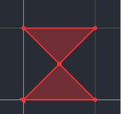
转换为2个三角形

2.16. ST_SymDifference(g1,g2)
- OceanBase(root@oceanbase)>SET @g1 = ST_GeomFromText('MULTIPOINT(5 0,15 10,15 25)');
- Query OK, 0 rows affected (0.001 sec)
-
- OceanBase(root@oceanbase)>SET @g2 = ST_GeomFromText('MULTIPOINT(1 1,15 10,15 25)');
- Query OK, 0 rows affected (0.001 sec)
-
- OceanBase(root@oceanbase)>SELECT ST_AsText(ST_SymDifference(@g1, @g2));
- +---------------------------------------+
- | ST_AsText(ST_SymDifference(@g1, @g2)) |
- +---------------------------------------+
- | MULTIPOINT((1 1),(5 0)) |
- +---------------------------------------+
- 1 row in set (0.004 sec)
2.17. ST_AsGeoJSON(g[,max_dec_digits[,options]])
- --flag 0(000)到7(111)表现
- OceanBase(root@oceanbase)>SELECT ST_AsGeoJSON(ST_GeomFromText('POINT(11.11111 12.22222)', 4326),1,0);
- +---------------------------------------------------------------------+
- | ST_AsGeoJSON(ST_GeomFromText('POINT(11.11111 12.22222)', 4326),1,0) |
- +---------------------------------------------------------------------+
- | {"type": "Point", "coordinates": [12.2, 11.1]} |
- +---------------------------------------------------------------------+
- 1 row in set (0.003 sec)
-
- OceanBase(root@oceanbase)>SELECT ST_AsGeoJSON(ST_GeomFromText('POINT(11.11111 12.22222)', 4326),1,1);
- +----------------------------------------------------------------------------------+
- | ST_AsGeoJSON(ST_GeomFromText('POINT(11.11111 12.22222)', 4326),1,1) |
- +----------------------------------------------------------------------------------+
- | {"bbox": [12.2, 11.1, 12.2, 11.1], "type": "Point", "coordinates": [12.2, 11.1]} |
- +----------------------------------------------------------------------------------+
- 1 row in set (0.001 sec)
-
- OceanBase(root@oceanbase)>SELECT ST_AsGeoJSON(ST_GeomFromText('POINT(11.11111 12.22222)', 4326),1,2);
- +--------------------------------------------------------------------------------------------------------------+
- | ST_AsGeoJSON(ST_GeomFromText('POINT(11.11111 12.22222)', 4326),1,2) |
- +--------------------------------------------------------------------------------------------------------------+
- | {"crs": {"type": "name", "properties": {"name": "EPSG:4326"}}, "type": "Point", "coordinates": [12.2, 11.1]} |
- +--------------------------------------------------------------------------------------------------------------+
- 1 row in set (0.001 sec)
-
- OceanBase(root@oceanbase)>SELECT ST_AsGeoJSON(ST_GeomFromText('POINT(11.11111 12.22222)', 4326),1,3);
- +------------------------------------------------------------------------------------------------------------------------------------------------+
- | ST_AsGeoJSON(ST_GeomFromText('POINT(11.11111 12.22222)', 4326),1,3) |
- +------------------------------------------------------------------------------------------------------------------------------------------------+
- | {"crs": {"type": "name", "properties": {"name": "EPSG:4326"}}, "bbox": [12.2, 11.1, 12.2, 11.1], "type": "Point", "coordinates": [12.2, 11.1]} |
- +------------------------------------------------------------------------------------------------------------------------------------------------+
- 1 row in set (0.001 sec)
-
- OceanBase(root@oceanbase)>SELECT ST_AsGeoJSON(ST_GeomFromText('POINT(11.11111 12.22222)', 4326),1,4);
- +-------------------------------------------------------------------------------------------------------------------------------+
- | ST_AsGeoJSON(ST_GeomFromText('POINT(11.11111 12.22222)', 4326),1,4) |
- +-------------------------------------------------------------------------------------------------------------------------------+
- | {"crs": {"type": "name", "properties": {"name": "urn:ogc:def:crs:EPSG::4326"}}, "type": "Point", "coordinates": [12.2, 11.1]} |
- +-------------------------------------------------------------------------------------------------------------------------------+
- 1 row in set (0.001 sec)
-
- OceanBase(root@oceanbase)>SELECT ST_AsGeoJSON(ST_GeomFromText('POINT(11.11111 12.22222)', 4326),1,5);
- +-----------------------------------------------------------------------------------------------------------------------------------------------------------------+
- | ST_AsGeoJSON(ST_GeomFromText('POINT(11.11111 12.22222)', 4326),1,5) |
- +-----------------------------------------------------------------------------------------------------------------------------------------------------------------+
- | {"crs": {"type": "name", "properties": {"name": "urn:ogc:def:crs:EPSG::4326"}}, "bbox": [12.2, 11.1, 12.2, 11.1], "type": "Point", "coordinates": [12.2, 11.1]} |
- +-----------------------------------------------------------------------------------------------------------------------------------------------------------------+
- 1 row in set (0.001 sec)
-
- OceanBase(root@oceanbase)>SELECT ST_AsGeoJSON(ST_GeomFromText('POINT(11.11111 12.22222)', 4326),1,6);
- +-------------------------------------------------------------------------------------------------------------------------------+
- | ST_AsGeoJSON(ST_GeomFromText('POINT(11.11111 12.22222)', 4326),1,6) |
- +-------------------------------------------------------------------------------------------------------------------------------+
- | {"crs": {"type": "name", "properties": {"name": "urn:ogc:def:crs:EPSG::4326"}}, "type": "Point", "coordinates": [12.2, 11.1]} |
- +-------------------------------------------------------------------------------------------------------------------------------+
- 1 row in set (0.001 sec)
-
- OceanBase(root@oceanbase)>SELECT ST_AsGeoJSON(ST_GeomFromText('POINT(11.11111 12.22222)', 4326),1,7);
- +-----------------------------------------------------------------------------------------------------------------------------------------------------------------+
- | ST_AsGeoJSON(ST_GeomFromText('POINT(11.11111 12.22222)', 4326),1,7) |
- +-----------------------------------------------------------------------------------------------------------------------------------------------------------------+
- | {"crs": {"type": "name", "properties": {"name": "urn:ogc:def:crs:EPSG::4326"}}, "bbox": [12.2, 11.1, 12.2, 11.1], "type": "Point", "coordinates": [12.2, 11.1]} |
- +-----------------------------------------------------------------------------------------------------------------------------------------------------------------+
- 1 row in set (0.001 sec)
2.18. ST_Centroid
- OceanBase(root@oceanbase)>SELECT ST_AsText(_ST_PointOnSurface(geom)) AS pt_on_surf,
- -> ST_AsText(ST_Centroid(geom)) AS centroid
- -> FROM (SELECT ST_GeomFromText('POLYGON ((0 0, 0 10, 10 10, 10 8, 2 8, 2 2, 10 2, 10 0, 0 0))') AS geom) AS t;
- +------------+----------------------------+
- | pt_on_surf | centroid |
- +------------+----------------------------+
- | POINT(1 5) | POINT(4.076923076923077 5) |
- +------------+----------------------------+
- 1 row in set (0.001 sec)
2.19. _ST_AsMVTGeom
- OceanBase(root@oceanbase)>SELECT ST_AsText(_ST_AsMVTGeom(ST_GeomFromText('POLYGON ((0 0, 0 -5, 10 0, 10 5, 0 0))'),ST_GeomFromText('POLYGON((0 0,0 4096,4096 4096,4096 0,0 0))'),4096, 0, false));
- +------------------------------------------------------------------------------------------------------------------------------------------------------------------+
- | ST_AsText(_ST_AsMVTGeom(ST_GeomFromText('POLYGON ((0 0, 0 -5, 10 0, 10 5, 0 0))'),ST_GeomFromText('POLYGON((0 0,0 4096,4096 4096,4096 0,0 0))'),4096, 0, false)) |
- +------------------------------------------------------------------------------------------------------------------------------------------------------------------+
- | POLYGON((0 4096,10 4091,10 4096,0 4101,0 4096)) |
- +------------------------------------------------------------------------------------------------------------------------------------------------------------------+
- 1 row in set (0.002 sec)
-
- OceanBase(root@oceanbase)>SELECT ST_AsText(_ST_AsMVTGeom(ST_GeomFromText('POLYGON ((0 0, 0 -5, 10 0, 10 5, 0 0))'),ST_GeomFromText('POLYGON((0 0,0 4096,4096 4096,4096 0,0 0))'),4096, 0, true));
- +-----------------------------------------------------------------------------------------------------------------------------------------------------------------+
- | ST_AsText(_ST_AsMVTGeom(ST_GeomFromText('POLYGON ((0 0, 0 -5, 10 0, 10 5, 0 0))'),ST_GeomFromText('POLYGON((0 0,0 4096,4096 4096,4096 0,0 0))'),4096, 0, true)) |
- +-----------------------------------------------------------------------------------------------------------------------------------------------------------------+
- | POLYGON((0 4096,10 4091,10 4096,0 4096)) |
- +-----------------------------------------------------------------------------------------------------------------------------------------------------------------+
- 1 row in set (0.001 sec)
2.20. 3维空间对象
3维空间对象ddl/dml与2维基本一致,只是3维空间对象无法写入到由子类型定义的字段上
- # 创建gis字段
- OceanBase(root@oceanbase)>create table geo_3d(g geometry);
- Query OK, 0 rows affected (0.302 sec)
-
- # 写入3维的点
- OceanBase(root@oceanbase)>insert into geo_3d values(ST_GeomFromText('POINT Z (0 0 0)'));
- Query OK, 1 row affected (0.025 sec)
-
- #查询3维数据
- OceanBase(root@oceanbase)>select st_aswkt(g) from geo_3d;
- +-----------------+
- | st_aswkt(g) |
- +-----------------+
- | POINT Z (0 0 0) |
- +-----------------+
- 1 row in set (0.007 sec)
-
- # 对3维空间对象做空间计算时,会先转换为2维;
- # 如下例所示point(0 0 0)和point(0 0 1)在3维空间下是不相交的,转换到2维就是相交的
- OceanBase(root@oceanbase)>select st_intersects(g, st_geomfromtext('POINT Z (0 0 1)')) from geo_3d;
- +------------------------------------------------------+
- | st_intersects(g, st_geomfromtext('POINT Z (0 0 1)')) |
- +------------------------------------------------------+
- | 1 |
- +------------------------------------------------------+
- 1 row in set (0.005 sec)
-
- # 部分表达式不支持3维数据
- OceanBase(root@oceanbase)>select st_x(g,1) from geo_3d;
- ERROR 3037 (22023): Invalid GIS data provided to function st_x.
-
- # 用子类型(point/linestring等)定义gis字段,不支持插入3维数据
- OceanBase(root@oceanbase)>create table t(geo point);
- Query OK, 0 rows affected (0.511 sec)
- # 可以写入2维数据
- OceanBase(root@oceanbase)>insert into t values(ST_GeomFromText('POINT(0 0)'));
- Query OK, 1 row affected (0.004 sec)
- # 无法写入3维数据
- OceanBase(root@oceanbase)>insert into t values(ST_GeomFromText('POINT Z (0 0 0)'));
- ERROR 1416 (22003): Cannot get geometry object from data you send to the GEOMETRY field.
3. 总结和展望
如上所述,本次特性为满足用户的需求,补充了部分ob mysql特有的gis空间表达式;同时补齐了部分兼容mysql gis的空间表达式。目前ob mysql gis提供的空间计算和分析的能力与mysql gis仍然有一定差距,将在后续的版本迭代中快速补齐相关功能。

